How To Evaluate Island Parcels Remotely

December 4, 2025

Buying an island parcel near Sitka from hundreds or thousands of miles away can feel like trying to read the shoreline through fog. You want a clear picture of access, tides, anchorage, and what you can actually build before you invest time and money. With the right media and a focused checklist, you can narrow great options fast and avoid costly surprises later. This guide shows you what to request, how to interpret it, and what to verify during an escorted visit. Let’s dive in.

Why Sitka islands are unique

Sitka sits within Southeast Alaska’s island-dotted coastline where land ownership is a mosaic of private uplands, state tidelands and submerged lands, federal holdings, and Native Corporation interests. You need to confirm who owns what, including subsurface rights, before you assume a future dock or float is possible.

Marine weather, tides, and currents shape day-to-day access. Winds and storm patterns ramp up in fall and winter, and tidal currents can accelerate in narrow channels. You will rely on nautical charts, local tide predictions, and real-time advisories to plan safe approaches.

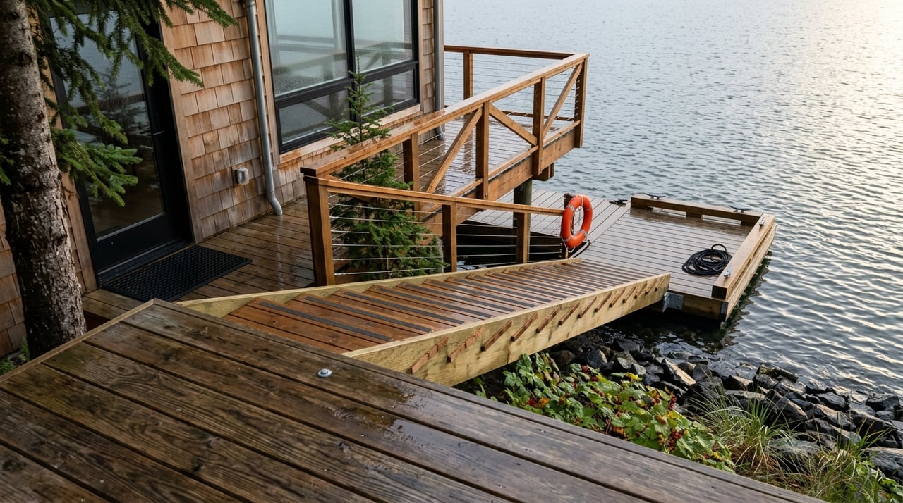
Access is typically by private boat, floatplane, or helicopter. Practical access depends on protected anchorages, beach landings, and proximity to Sitka Harbor. Because the region holds important fish habitat and cultural resources, early coordination with the right agencies and tribes is wise if you plan ground-disturbing work.

Request the right media

Ask the seller or listing agent for a media package that lets you evaluate the parcel from your desk. Prioritize:

  • High-resolution drone video and photos, geotagged if possible, from multiple headings and altitudes.
  • A shoreline-approach video filmed from a boat at a specified tide height.
  • Any photogrammetry outputs: orthomosaic and digital surface model (DSM) with notes on accuracy and ground control points.
  • Interior walkthroughs for structures, such as Matterport, plus exterior deck and entry captures.
  • The relevant nautical chart numbers and edition dates, plus topographic map references.
  • Recorded deed, any survey or plat, tideland conveyance documents, and existing permits.
  • Documentation of easements or rights-of-way for marine or air access.
  • Utility information: screenshots of cell coverage on site, possible internet options, and nearest fuel access.

Request original files when possible. For mapping, ask for GeoTIFFs and any flight logs. Clear file names, dates, and tide notes make review much easier.

Read drone footage like a pro

Drone media is your first pass at access and buildability. Review it with a checklist in hand:

  • Shoreline: Identify rocky benches, boulder slopes, sand or mud, and the width of the intertidal zone.
  • Slope: Note how quickly the land rises from the water and where gentle benches exist.
  • Vegetation and wetlands: Look for mature conifers, alder thickets, standing water, or obvious wetlands.
  • Improvements: Document docks, stairs, trails, cabins, and their apparent condition from multiple angles.
  • Stability: Scan for erosion, slumps, or recent slide scars near the shoreline and on bluffs.
  • Hazards: Spot kelp beds, reefs, or shoals that affect approach and anchoring.

Drone video cannot show underwater contours in turbid water. Use it to narrow candidates, not to make final anchorage decisions.

Use charts and topos together

Nautical charts are essential for approach planning. Focus on:

  • Depth contours, rocks, kelp, and marked hazards along your likely route.
  • Aids to navigation, reported channels, and any recommended anchorages.
  • Bathymetry nearshore, which influences floatplane and skiff operations.

Pair charts with topographic maps to read slope, drainage, and possible runoff paths. Check current tide predictions for Sitka and look up recent notices to mariners for updated hazards. Chart scale and edition date matter; always note both.

Add 3D and interior media

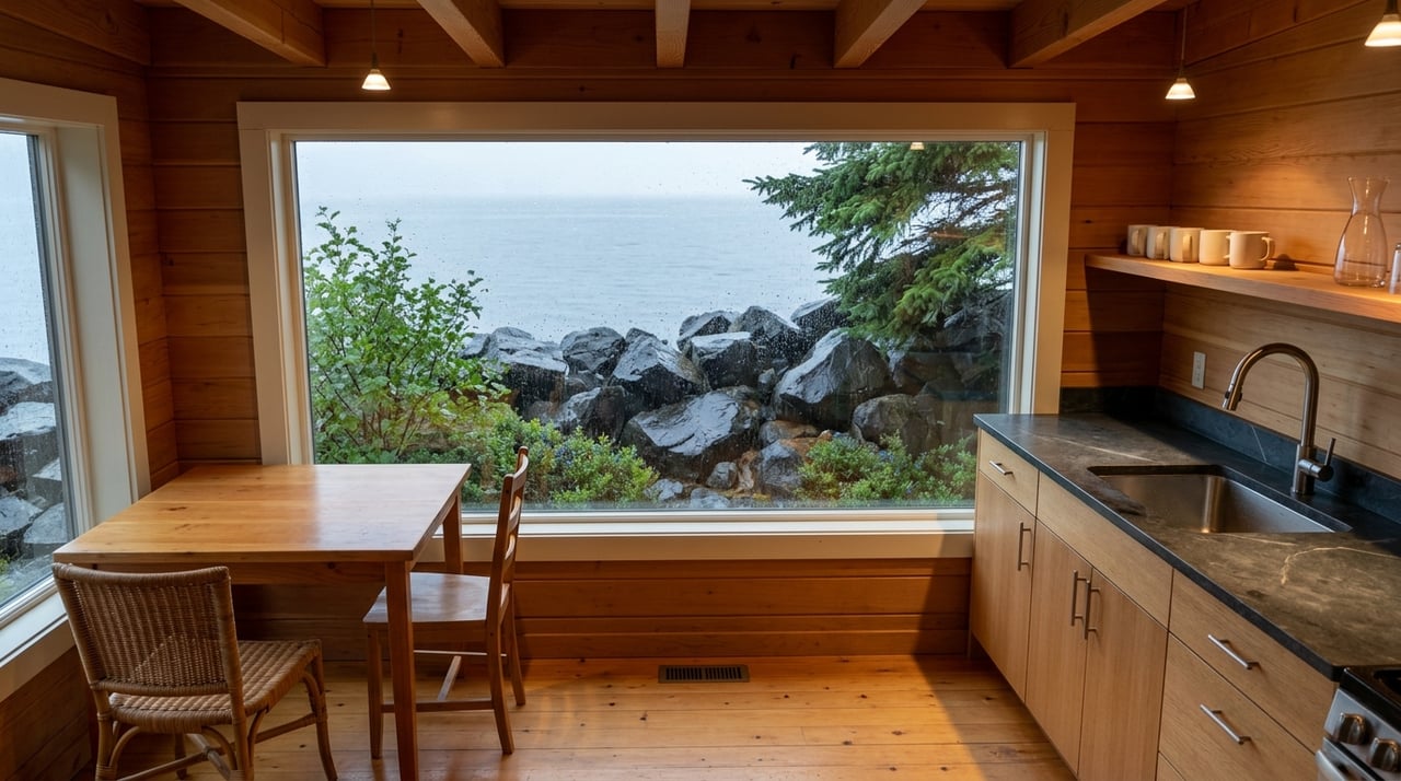
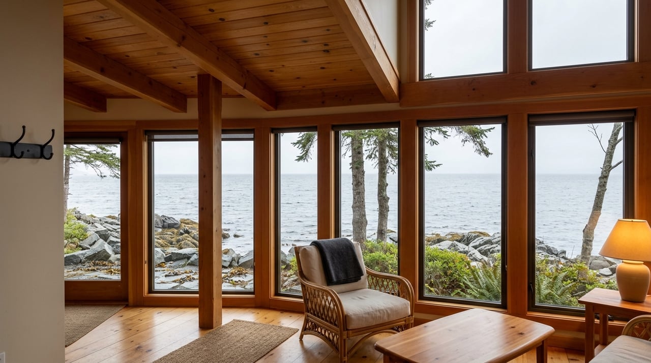
Matterport and similar 3D tools help you assess cabin condition, visible systems, and immediate exterior areas. Ask for supplemental exterior captures or panoramic scans so you can inspect entries, decks, and transitions to the shoreline. Remember that interior media rarely covers the full parcel or intertidal zone.

Confirm title and tidelands early

Value and permitted uses hinge on ownership details. Confirm the recorded deed and any reservations or exceptions. Request a recent boundary survey if one does not exist, especially for islands where shorelines can change.

Determine whether adjacent tidelands and submerged lands were conveyed or remain state-owned. This affects your ability to install or maintain docks, floats, and other water-dependent structures. If Native Corporation lands or interests are nearby, contact the appropriate regional or village corporation for title history and restrictions.

Verify any recorded access easements and clarify whether current access depends on informal use. Ask your agent for Sitka Borough tax classification and whether special assessments or harbor fees may apply.

Plan for seasons and safety

Ask the listing agent to specify seasonal windows and limitations. You want to know when floatplane landings are workable and when offshore approaches become risky. Note prevailing seasonal winds and the months when beach landings are most reliable.

Evaluate anchorage by combining media and charts. Watch for kelp that can foul props, submerged rocks, and tight channels where currents speed up. If anchoring is critical, plan on in-person depth soundings and a bottom survey to confirm holding ground.

Review seismic, tsunami, and coastal erosion considerations when siting structures. Historical imagery can reveal shoreline change, and conservative setbacks help with long-term resilience.

Build your due diligence file

As you compare parcels, keep a clean folder with:

  • Surveys, deeds, plats, and any recorded easements or rights-of-way.
  • Tideland conveyance records and copies of existing permits or approvals.
  • Photogrammetry files, drone media, and flight logs with dates and tide notes.
  • NOAA chart references, tide predictions, and any relevant advisories.
  • Septic feasibility information and local onsite wastewater standards.
  • Cell coverage screenshots, internet options, and notes on fuel availability.

Having complete, date-stamped documentation speeds attorney review and offer preparation.

Verify with an escorted visit

Once a parcel passes your remote screen, schedule an escorted visit during the season you plan to use the property. Before you travel, review surveys, deeds, media, and tide plans, and confirm a safe landing plan with alternates.

On site, prioritize these tasks:

  • Boundaries: Walk lines, locate monuments, and compare to the legal description.
  • Shoreline: Inspect at the same tide height shown in listing media; note erosion, substrate, and structures.
  • Bathymetry: Take depth soundings along approach lanes and proposed anchorage; test anchor holding if feasible.
  • Structures: Inspect docks, floats, and buildings for condition, drainage, and fasteners.
  • Septic and soils: Perform or verify percolation tests and identify potential drainfield sites.
  • Freshwater: Locate springs or wells and test for quality and flow; estimate rain catchment and storage if needed.
  • Communications and power: Test cell carriers, satellite internet, VHF radio, and any generator or solar systems.
  • Environmental and cultural checks: Watch for fish-bearing streams, eelgrass, artifacts, or features that indicate sensitivity.

Bring or line up the right professionals as needed, such as a licensed surveyor, marine surveyor, septic designer, geotechnical engineer, and an environmental consultant if wetlands or fish habitat are present.

Smart questions for the seller

Use your site time well with direct questions:

  • What access rights are recorded, and have there been any disputes?
  • Has the shoreline moved or been stabilized, and when?
  • Which structures were permitted, and are permit records available?
  • Have there been seasonal access challenges, and during which months?
  • Are there known neighbor concerns or no-anchoring zones nearby?

Your next steps

  • Request a complete media and document set: surveys, deed, permits, geotagged drone footage, and chart references.
  • Have a local attorney or title company run a title report and search tideland conveyance and easements.
  • Arrange a reconnaissance visit with a surveyor and marine surveyor to validate anchorage and boundaries before making an offer.
  • If you move forward, plan an escorted visit during your intended use season with the right consultants.

If you want an experienced local partner to package media, coordinate logistics, and keep your evaluation grounded in Sitka reality, reach out to Suzanne Marina Jasso to Request a Virtual Tour or Local Consultation. You will get clear media, practical context, and a smart path from first look to confident decision.

FAQs

What should remote Sitka island buyers request first?

  • Ask for a geotagged drone package, any surveys and deeds, chart numbers and edition dates, and notes on tide height during filming.

How do nautical charts help evaluate access?

  • Charts show depths, rocks, kelp, and hazards so you can identify safe approach lanes, protected anchorages, and floatplane feasibility.

Why do tidelands matter for private islands?

  • Ownership or rights to adjacent tidelands and submerged lands affect whether you can permit and maintain docks, floats, or shoreline structures.

Can Matterport replace an in-person inspection?

  • No. Matterport helps assess interiors and immediate exteriors, but you still need on-site checks for shoreline, anchorage, soils, and structures.

When is the best season to visit a Sitka island parcel?

  • Visit during the season you plan to use it most, and confirm prevailing winds, tide windows, and typical storm patterns for that period.

Which professionals should join an escorted visit?

  • Consider a licensed surveyor, marine surveyor, septic designer, geotechnical engineer, and an environmental consultant if habitat or wetlands are present.

Here to Guide You

I know that hard work, knowledge and dedication are required to earn my client's business, respect, and most importantly their trust. I would be honored to work with you in any real estate dealings