How To Evaluate Southeast Alaska Waterfront Parcels
April 16, 2026
April 16, 2026
Buying a waterfront parcel in Sitka can feel exciting right up until one simple question changes everything: what, exactly, are you buying and what can you actually do with it? In Southeast Alaska, shoreline ownership, access, terrain, utilities, and permitting can all shape a parcel’s real value. If you are looking at raw land for a cabin, future home, dock, or long-term hold, this guide will help you evaluate the right details early and avoid costly assumptions. Let’s dive in.
On a Sitka waterfront parcel, the first step is not the view. It is the boundary. In Alaska, the state generally owns most tidelands and submerged lands along the coast, while the upland parcel may stop at or near the mean high water line, which NOAA defines as the intersection of land with water at mean high water. You can review Alaska’s ownership framework in the Alaska DNR tidelands and submerged lands fact sheet.
That matters because a parcel that looks like it includes beach frontage or a usable shoreline may not include the tidelands you expect. If your plans involve shoreline use, marine access, or future improvements near the water, you will want to know whether the legal description covers only uplands or also includes some tideland interest.
A smart first pass is to pull the parcel in Alaska Mapper and compare it with local mapping from Sitka Planning & Zoning. Still, DNR makes clear that Alaska Mapper is only a graphic illustration, not the official record. Sitka’s GIS materials also require independent verification, so map review should lead to title, survey, and agency follow-up, not replace it.
If a project reaches state-owned tidelands, DNR says an Alaska State Tideland Survey is required after lease or conveyance approval, and many of those surveys require the mean high water line to be located. That is one reason waterfront due diligence often needs more than a standard lot-line review.
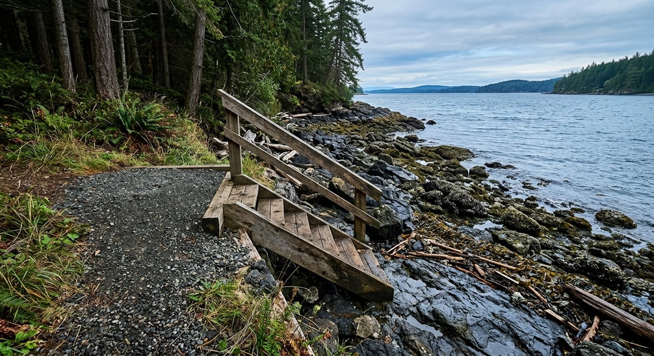
Not all waterfront is equally usable. A parcel with beautiful exposure can still be difficult to build on, access, or improve. In Sitka, shoreline character can vary from rocky shore and tidal flat to marsh, bluff, sand, or gravel beach, and each condition affects how the land functions.
For a more detailed look, NOAA’s Alaska ShoreZone program and shoreline classification guidance can help you understand coastal imagery, habitat context, and shoreline type. That can give you an early sense of whether the frontage is sheltered or exposed and whether the shore appears stable, steep, soft, or hard.
You should also look beyond the actual shoreline. Ask whether there is enough usable upland for a house pad, cabin site, parking area, or access path. A waterfront lot can look generous from the water but still require major grading, retaining walls, stairs, or fill before it becomes practical.
A scenic parcel is not automatically a buildable parcel. Sitka’s subdivision code states that lands with hazards such as flooding, snow avalanches, rockfalls, landslides, unstable slopes, subsidence, high water table, or other health and safety issues should not be developed or subdivided unless those hazards are eliminated or overcome through approved design and construction plans. You can review that standard in the Sitka municipal code.
This is why you should pay close attention to slope, drainage, and signs of erosion. If the parcel shows bluff retreat, tidal overwash, standing water, or obvious instability, those are not minor details. They can affect design options, project cost, and whether a lender or insurer views the property favorably.
Flood review matters too. The official place to check mapped flood hazards is FEMA’s Flood Map Service Center. Even if a parcel is not in a mapped flood hazard area, that should not be treated as a guarantee of easy development. It is one layer of the review, not the whole answer.
Many buyers assume access is straightforward if a parcel appears reachable on a map. In Alaska, that assumption can cause problems. According to DNR, legal access may come through section-line easements, platted rights-of-way, trail easements, navigable water bodies, or across unreserved state-owned land, but legal access is not the same as practical access. The state also does not have to build roads or provide services. DNR explains this clearly in its access guidance.
For a Sitka waterfront parcel, this means you need to ask whether access is deeded road access, trail access, or boat-only access. Boat access may be perfectly acceptable for your goals, but it should be a deliberate choice, not a surprise discovered late in the process.
Easement research is just as important. DNR notes that easements are commonly used for access, utilities, and erosion or water-control systems. If utility lines, a driveway, or shoreline protection depend on land outside the deeded parcel, you need to know that early.
Utilities can make or break a land purchase, especially on waterfront and partially remote parcels. Sitka’s utility fact sheet shows that city utility billing can include electricity, water, wastewater treatment, garbage, refuse drop charges, landfill charges, finance charges, and sales tax. The city also notes that its sanitary sewer system is operating near target capacity, which is a good reminder to confirm service availability directly instead of assuming it will be easy to connect. See the city’s utility customer fact sheet.
If city services are not available, you may need to evaluate on-site water and wastewater options. That review should be grounded in actual site conditions, including slope and soils, not just what worked on another parcel nearby.
DEC says on-site wastewater systems must be approved or registered under its rules, and existing documentation should be checked in EDMS. DNR also notes that projects disturbing one acre or more may need CGP coverage through a Notice of Intent, so even site clearing can trigger additional review.
For some buyers, the whole point of a waterfront parcel is marine access. If that is true for you, dig into the logistics early. A property may have shoreline frontage without offering the kind of docking or moorage setup you have in mind.
Sitka’s Harbor Department oversees harbor regulations, and moorage is assigned by the Harbormaster. If your plans depend on nearby harbor infrastructure, assigned moorage, or specific boat-use logistics, review the Sitka Harbor regulations as part of your due diligence.
One of the biggest mistakes buyers make is assuming a parcel can support a dock, fill project, road extension, or septic solution just because it seems physically possible. On waterfront land, the permit path often determines what is realistic.
Sitka Planning & Zoning assists with variances, conditional use permits, zoning amendments, subdivisions, tideland leases, and municipal land sales. The city also notes that the waterfront district is intended for lands with direct access or close proximity to navigable tidal waters within the urban area, with emphasis on water-dependent or water-related uses. You can start with Sitka Planning & Zoning.
The city’s Building Department says submittal requirements vary by project, from a simple diagram to a full plot plan, floor plan, and elevations for a new home. That makes early contact worthwhile when a parcel has steep ground, flood concerns, or difficult access.
The U.S. Army Corps of Engineers says Section 10 approval is required for work in, over, or under navigable waters, including things like piers, ramps, floats, dredging, and fill work. ADF&G also states that any activity below the ordinary high water mark of an anadromous stream requires a Fish Habitat Permit. On a Southeast Alaska parcel, that can be a critical issue if a stream is nearby.
If you are trying to compare more than one Sitka waterfront parcel, it helps to follow the same due-diligence order every time. Based on the available agency guidance, this is a practical sequence:
This order can save you time and keep you from getting emotionally attached to a parcel before the fundamentals are clear.
Waterfront parcels in Sitka can be exceptional, but they often require more layered due diligence than inland residential lots. Boundaries may not line up with what the eye expects. Access may be legal but not practical. And improvements that seem straightforward can involve multiple agencies once tidelands, navigable waters, habitat, or steep terrain enter the picture.
That is where local context matters. When you are evaluating island, waterfront, or remote property in Southeast Alaska, it helps to work with someone who understands both the land and the process. If you are considering a parcel in Sitka and want grounded, local insight, connect with Suzanne Marina Jasso for a local consultation.


I know that hard work, knowledge and dedication are required to earn my client's business, respect, and most importantly their trust. I would be honored to work with you in any real estate dealings